The Shadow Mountains, located in the north central Mojave desert, were formed on the south western continental margin of the North American plate and have not been significantly displaced from their site of origin. They are the largest exposure of meta-sedimentary rock in the Mojave Desert region. As such, they make a good case study of the geologic history of southern California.
About 1700 million years ago the western boundary of the North American plate was a passive margin with the Mojave Desert area as the northwest-facing boundary. At 550 million years ago the western part of the North American continent was rifted (torn apart) from another continental mass that was carried away. The result was a period of extension in which the western part of the North American plate was thinned as rifting occurred. The plate boundary became a passive convergent margin that lasted form 550-220 million years ago when the pacific plate and the North American plate started heading toward each other. A volcanic arch formed in the shallow sea and miogeoclinal (continental sediments deposited in the sea) sedimentation began. From 220-70 million years ago the volcanic arch moved eastward, on top of the miogeoclinal sediments.
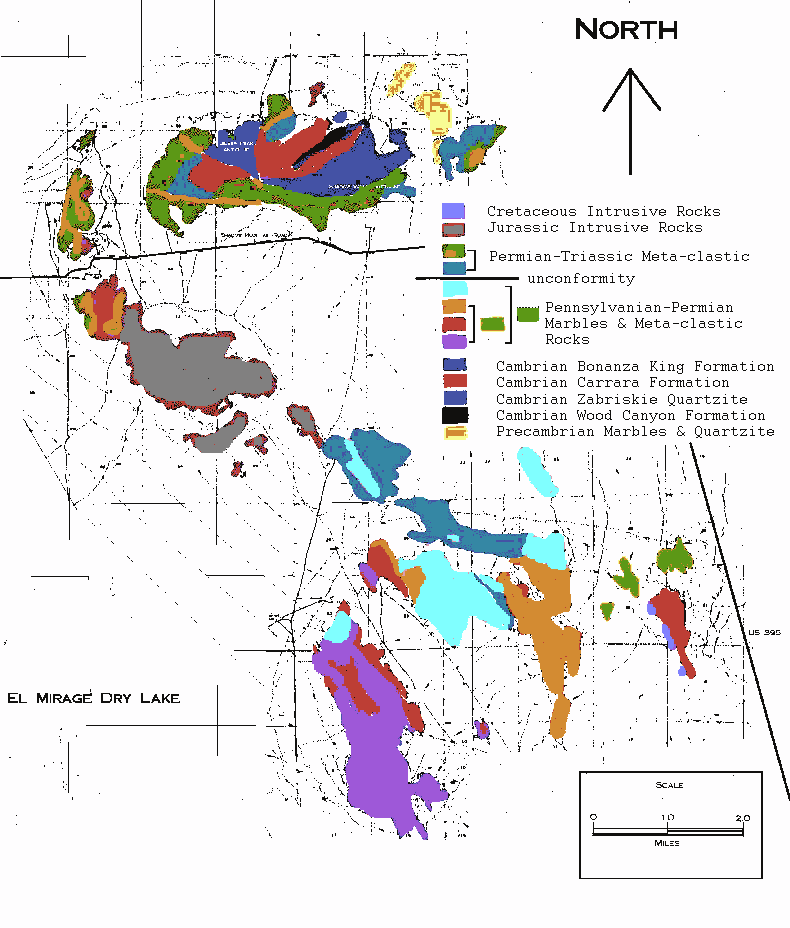
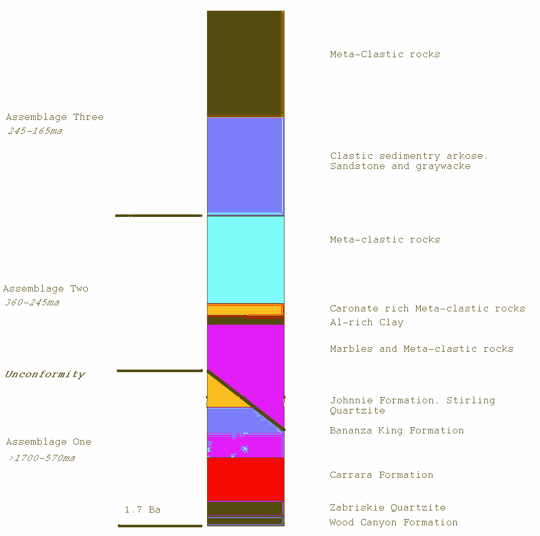
Many of these events are seen in the Shadow Mountains rock record. These rocks can be classified into three assemblages of sedimentary deposits the oldest of which is greater than 1.7 billion years old. The sedimentary rocks of the Shadow Mountains are intensely deformed and metamorphosed. There are at least two north-south ductile folds. The first event is a kilometer wide overturned anticline at Silver Peak. The second is a shear zone around the Silver Peak and Shadow Valley anticlines. These folds are associated with the intrusive gabbro/granite uplift 165 million years ago (Fig 1).
Assemblage one is located in the northern Shadow Mountains and is made up of five distinct rock layers of >570 million years old. The oldest rocks are the core of the Silver Peak anticline made up of 20-30 meter thick Wood Canyon Formation. The second is a 30-40 meter thick Zabriskie Quartzite which has been radiometericly dated at 1.7 billion years old. The third is 120 meters thick Carrara Formation. The forth and thickest layer in assemblage one is the 720 meter thick Bonanza King Formation. The last layer is 120-150 meters thick and consist of a combination of Johnnie Formation, Stirling Quartzite, and lower to middle Wood Canyon Formation. All of these layers are highly metamorphosed miogeoclinal sequences nearly identical to Quartzite Mountain in the Mojave. The rocks found are quartz-biotite schist, pink to white quartzite and meta-arkose, siliceous calcite marble, and dolomite marble (Fig 2). These rocks were deposited in a sea environment at or near a coastline. Between assemblage one and two there is an unconformity. It is not clear if this unconformity is due to erosion or non deposition at this site (Martin).
Assemblage two is located in the southern Shadow Mountains and is made up of 360-245 million years old deep marine deposits including some brachiopods. There is a high angle fault contact with the Bonanza King Formation. Assemblage two is made up of four distinct layers of rock types. The first is a 500 meter thick mass flow deposits. The second is a thin 5-30 meter Al-rich clay that may have been derived from beach sand. The third is a carbonate rich platform 20-30 meters thick. The last being a 750 meter thick turbiditic mass flow formation indicating a submarine canyon environment (Fig 2). All of these layers are consistent with a borderland because they were deposited in isolated basins related to the left lateral strike-slip and thrust faults associated with the truncation of the southwest North American margin. The rocks found are layered calcite marble, orange-brown feldsparthic quartzite, and dolomite (Martin).
Assemblage three is 2000 meter thick and is made up of 245-165 million years old marine carbonate rocks which have experienced plutonic intrusions. It can be dividend into two sections. The first of which is a clastic sedimentary arkose, sandstone and graywacke that show volcanic rocks similar to the El Paso Mountains. The volcanic rocks are a magmatic deposition in a marine to near marine environment. The second is of a marine origin >165 million years old (Fig 2). Assemblage three was deposited near sea level and most of the uplift of the Shadow Mountains happened at this time. The rocks consist of massive hornfels, quartzite, feldsparthic quartzite, cal-silicate rocks, calcite marble, talc-chlorite schist, siliceous hornfels and quartz-biotite schist. These are the last sedimentary rocks deposited in the Shadow Mountains (Martin).
The gabbro/granitic intrusive rock. The complex was intruded as a hydrous magma with 1700 million years old sedimentary inclusions. The magma chamber is circular in shape, 3-4 km in diameter, with good banding. The gabbro is nearly identical to the Seria Nevada 400 km to the north and is considered to be the southern most extension of the Sierra Nevada magmatic intrusion. It is also very similar to other Mojave Desert and Transverse Range gabbros. The granitic intrusion is widely considered to be the extension of the Independence dike (Smith).
The Stratigraphic record shows important implications for the southwestern North America continent. First, the passive margin of the late-Proterozoic early-Paleozoic miogeoclinal sediments extend as far west as the Shadow Mountains. Second, the presence of Pennsylvian and Permian borderland basin sediments suggest tectonic activity during the transformation from a passive to active plate margin 550 million years ago. Third, the magma chamber records the onset of convergent margin tectonics and magmatism in the Mojave Desert.
Smith, David K., Cohen, Lewis H., 1996, "Shallow Mesozoic layered gabbros of the Shadow Mountain, San Bernardino County, California", Journal of Volcanology and Geothermal Research, vol 73; p. 267-283